Multispectral drones help you detect crop stress early by capturing detailed plant health data across different spectral bands, well before visible signs appear. They enable you to monitor soil health, identify pest issues, and map problem zones precisely. By acting on this real-time information, you can make targeted interventions that save costs and boost yields. Keep exploring to discover how this technology can transform your farm management and keep your crops healthy.
Key Takeaways
- Multispectral drones detect early signs of crop stress by capturing plant responses across various spectral bands.
- They enable proactive management through regular monitoring, preventing yield loss due to stress.
- The technology helps identify soil health issues affecting plant growth, guiding targeted interventions.
- Multispectral imaging reveals pest infestations early, allowing timely and precise pest control measures.
- Drone-based spectral data improves decision-making with detailed field maps for resource optimization.
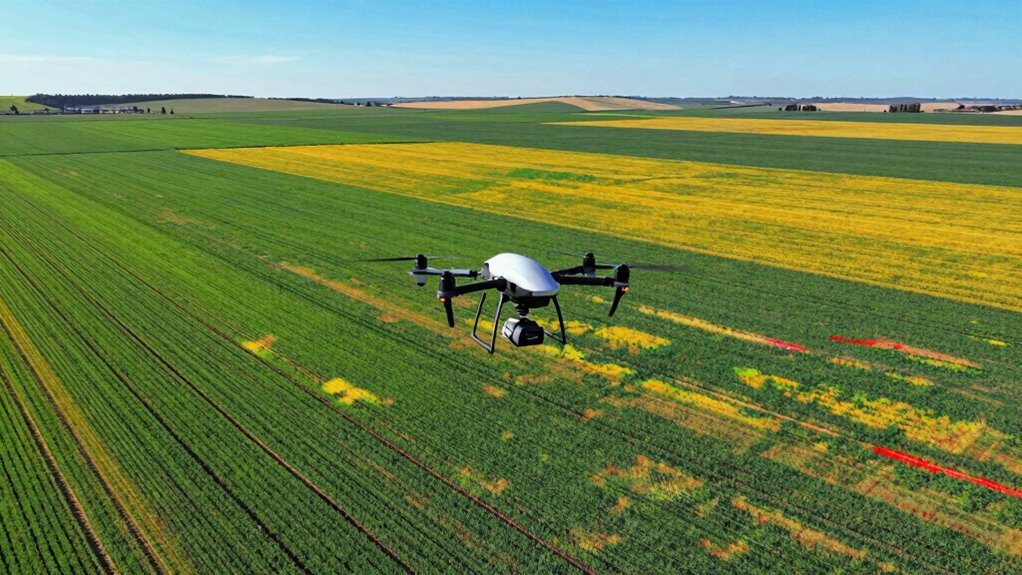
Have you ever wondered how farmers can detect crop stress early enough to prevent yield loss? The answer lies in the innovative use of multispectral drones, which provide detailed insights into plant health that aren’t visible to the naked eye. These drones fly over fields, capturing data across various spectral bands, allowing farmers to analyze specific plant responses related to soil health and pest management. By regularly monitoring crop conditions with multispectral imaging, you can catch signs of stress before they turn into full-blown problems, giving you time to act effectively.
Multispectral drones reveal hidden crop stress early, helping farmers act proactively to protect yields and improve farm health.
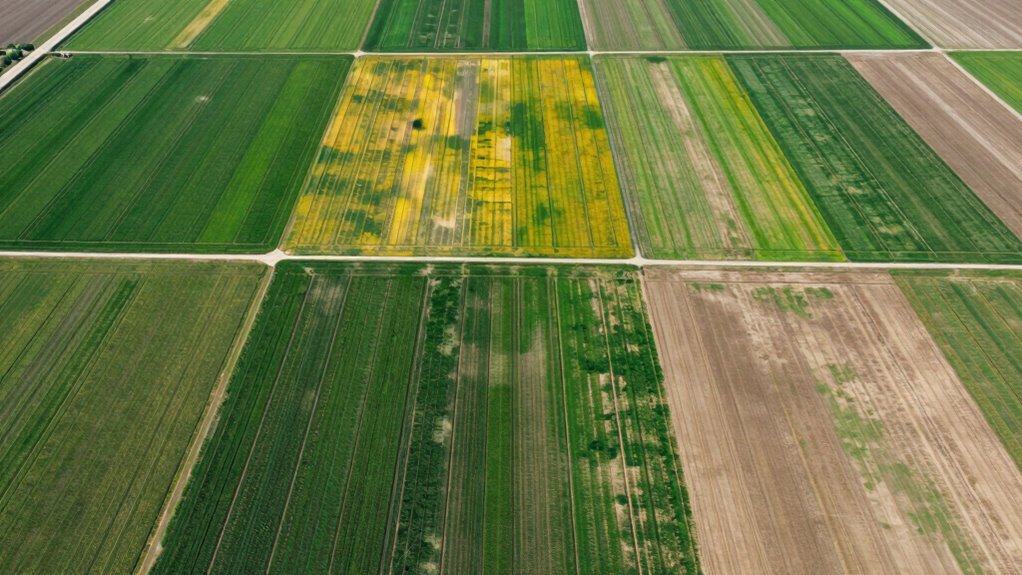
Soil health plays an essential role in crop vitality, and multispectral drones help you assess it indirectly. Variations in soil nutrients, moisture levels, and compaction influence plant growth, and these factors can cause stress that’s hard to detect visually. Using multispectral data, you can identify areas where soil conditions might be causing plants to weaken, such as zones with poor nutrient uptake or inadequate water retention. Early detection means you can target interventions like fertilization or irrigation precisely where needed, improving overall soil health and, consequently, crop resilience. Incorporating spectral imaging into your management practices enhances the accuracy of these assessments.
Pest management is another critical aspect where multispectral drone technology shines. Pests often cause subtle changes in plant health that are difficult to spot until significant damage has occurred. With multispectral imaging, you can identify early signs of pest infestation by observing changes in plant reflectance, such as chlorophyll degradation or stress-related discoloration. This early warning system enables you to deploy pest control measures promptly, reducing the need for blanket pesticide applications that can harm beneficial insects or lead to resistance. By pinpointing problem areas quickly, you not only protect your crops but also promote sustainable pest management practices.
The use of multispectral drones allows you to create detailed maps of your fields, highlighting zones of concern with high precision. This targeted approach optimizes resource use, saves costs, and minimizes environmental impact. Instead of relying on traditional scouting methods, which can be time-consuming and less accurate, you get real-time, actionable data that enhances your decision-making process. The integration of drone technology into your crop management routine means you’re better equipped to handle challenges related to soil health and pests, ultimately boosting your yields and farm profitability.

DJI P4 Multispectral Agriculture Drone, 3-Axis Stabilized Camera, RGB + 5 Multispectral Sensors, RTK Module, 27-Min Flight Time, 4.4-Mile Range
MULTISPECTRAL IMAGING: Advanced 6-camera array system featuring RGB camera for visible light plus 5 specialized cameras capturing multiple…
As an affiliate, we earn on qualifying purchases.
As an affiliate, we earn on qualifying purchases.
Frequently Asked Questions
How Do Multispectral Drones Differ From Other Aerial Imaging Methods?
Multispectral drones differ from other aerial imaging methods through their high spectral resolution, capturing specific wavelength bands that reveal plant health details invisible to standard cameras. You can leverage their data integration capabilities to combine multispectral data with other sources for all-encompassing analysis. This precision allows you to detect crop stress early, optimize interventions, and improve yields more effectively than traditional imaging methods, which often lack the spectral detail needed for such insights.
What Are the Limitations of Multispectral Drone Technology in Agriculture?
You may face limitations with multispectral drone technology in agriculture, especially if sensor calibration isn’t precise, leading to inaccurate data. Additionally, integrating multispectral data with other sources can be complex and time-consuming. Weather conditions like clouds and wind can also hinder drone flights, reducing data quality and coverage. These factors can impact the effectiveness of crop stress detection, making it essential to maintain calibration routines and streamline data integration processes.
How Accurate Is Crop Stress Detection Using Multispectral Drones?
Crop stress detection with multispectral drones is like reading a detailed map—you get precise insights. Their accuracy depends on spectral resolution and data analysis quality. Higher spectral resolution captures specific stress indicators, enhancing detection precision. When combined with thorough data analysis, you can identify stress early and accurately. While not perfect, this technology offers reliable results, helping you make informed decisions to optimize crop health and yields.
What Is the Typical Cost of Deploying Multispectral Drones for Farms?
The typical cost of deploying multispectral drones for farms ranges from $10,000 to $50,000, depending on the drone’s capabilities and features. You should consider cost considerations and include them in your budget planning to guarantee a smooth implementation. Keep in mind that expenses may include the drone itself, sensors, maintenance, training, and data processing software, so budgeting carefully helps optimize your investment and operational efficiency.
How Can Farmers Interpret Multispectral Drone Data Effectively?
You can interpret multispectral drone data effectively by focusing on soil moisture levels and pest identification. Start by analyzing the NDVI and other indices to spot areas with low soil moisture, indicating potential stress. Look for pest hotspots marked by unusual spectral signatures. Regularly compare data over time to track changes, helping you make informed decisions about irrigation and pest control. This approach guarantees healthier crops and optimized resource use.

Police Drone Detection & Tracking Kit Handheld Drone Detection Kit- Compact Remote ID Receiver for iOS & Android
✅ Real-Time RF Drone Detection: Instantly detects drones using radio frequency remote ID signals VERSATILE DETECTION: Handheld device…
As an affiliate, we earn on qualifying purchases.
As an affiliate, we earn on qualifying purchases.
Conclusion
By using multispectral drones, you’re like a vigilant guardian watching over your crops, catching signs of stress early before they turn into bigger problems. These drones give you a clear, detailed view of your fields, helping you make smarter, faster decisions. Just as a lighthouse guides ships safely to shore, multispectral technology guides your farming practices toward healthier, more resilient crops. Embrace this innovative tool and watch your fields thrive like a well-tuned symphony.
DJI P4 Multispectral Agriculture Drone, 3-Axis Stabilized Camera, RGB + 5 Multispectral Sensors, RTK Module, 27-Min Flight Time, 4.4-Mile Range
MULTISPECTRAL IMAGING: Advanced 6-camera array system featuring RGB camera for visible light plus 5 specialized cameras capturing multiple…
As an affiliate, we earn on qualifying purchases.
As an affiliate, we earn on qualifying purchases.

DronePoints – White Aerial Target Kit (Complete) – 12" Diameter – 20 Pack – Ground Control Target & Stencil System for Drone Mapping & Survey
Complete Kit Includes – 20 Aerial Targets, 20 adhesive-backed center markers, 20 60D nails with adapters, 1 removal…
As an affiliate, we earn on qualifying purchases.
As an affiliate, we earn on qualifying purchases.